6/18/2007

Monthly rain rate. Time animation.


View as slideshow

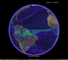
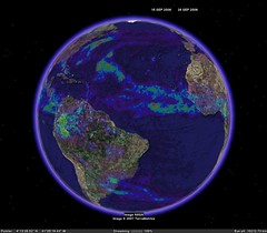
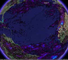
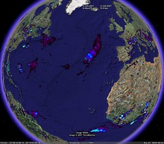
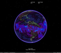
KML Network link to time animated monthly rain rate, mm/hr
WMS+Spreadsheets.

Time: 2004-05-01 2007-04-01
Step: 1 month
Time of interests: 3 years (np make more)
By animation you can uses cursor width = 30-60 days

Credits:
http://disc2.nascom.nasa.gov/Giovanni/tovas/realtime.3B42RT.2.shtml#description
http://disc.gsfc.nasa.gov/services/wxs_ogc.shtml


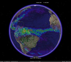
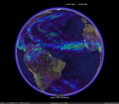
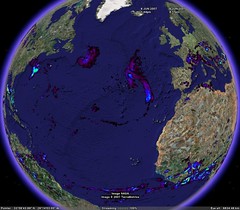
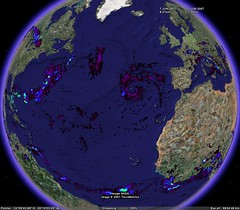
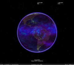
Monthly accumulated rain.
KML Network link to time animated monthly accumulated rain, mm

Monthly rain rate spreadsheets


Monthly accumulated rain spreadsheets

6/14/2007

KMLer 2.0.5

Build: 13.06.2007
- Small bugs is fixed
- KMLer wokrs correctly with any system number decimal separator now (".",",")

Version 2.0.5
Build: 14.06.2007
- Feature class metadata is added to output kml file

Home page
Download last version

6/11/2007

Accumulated rainfall daily (mm). Time animation.


Download KML network link.
View as slide show http://www.flickr.com/photos/valery35/sets/72157600327956879/show/

Accumulated rainfall daily (mm). Time animation.
Network link to time animated Rain rate (mm\hr).
WMS+Spreadsheets.
Product name: TRMM_3B42_V6_DAILY

Time=UTC
Time Shift: 2 months
Step: 1 day
Time of interests: 30 days
By animation you can uses cursor width = 1-2 days.

Spreadsheets: http://spreadsheets.google.com/pub?key=phRmoRD2Q-V_omnszDvvOMQ

Credits:
http://disc2.nascom.nasa.gov/Giovanni/tovas/realtime.3B42RT_daily.2.shtml
http://disc.gsfc.nasa.gov/services/wxs_ogc.shtml


Superoverlay 1.7.1

Fixed bugs with georeference.

Download last version.
Home page.
Docs.

6/09/2007

Rain rate. Time animation.


View as slide show http://www.flickr.com/photos/valery35/sets/72157600327956879/show/

Download KML network link

TRMM_3B42RT_3H
Network link to time animated Rain rate (mm\hr).
WMS+Spreadsheets.

This updated now by refresh of spreadsheets and not need edition.
Shift of time: 12 hours
Step: 3 hours
Time of interests: 3 days (np make more)
List of images updated automatically every 5 min!
By animation you can uses cursor width = 3-6 hours.

Spreadsheets: http://spreadsheets.google.com/pub?key=phRmoRD2Q-V9L8erXf9vCLA

Credits:
http://disc2.nascom.nasa.gov/Giovanni/tovas/realtime.3B42RT.2.shtml#description
http://disc.gsfc.nasa.gov/services/wxs_ogc.shtml

Quote:

Experimental Real-Time TRMM Multi-Satellite Precipitation Analysis (TMPA-RT):

Why Study Tropical Rainfall?

The Tropical Rainfall Measuring Mission (TRMM) is a joint U.S.-Japan satellite mission to monitor tropical and subtropical precipitation and to estimate its associated latent heating. Motivations include:

* The tropics play an important role in the global hydrological cycle, and tropical rainfall is the critical component of this role. Three-fourth of the atmosphere's heat energy derives from the release of latent heat of condensation in the process of precipitation. Two-thirds of the global precipitation occurs in the tropics.
* The variability of tropical rainfall affects the lives and economics of more than half of the world's population.
* The large spatial and temporal variability of rainfall systems poses a major challenge to estimating global rainfall.

TRMM provides systematic, multi-year, visible, infrared, and microwave measurements of rainfall in the tropics as key inputs to weather and climate research. The satellite observations are complemented by ground radar and rain gauge measurements to validate the satellite rain estimation techniques.


6/08/2007

KMLer 2.0.4 and Superoverlay 1.7.0


KMLer new Version 2.0.4
Build: 07.06.2007

- For PRO version only: Create overlays function supports Superoverlay projects creation now directly from your ArcMap project.
You should only download and install Superoverlay 1.7.x or later and use your KMLer Pro license to obtain standard Superoverlay version.
IMPORTANT ! Doesn't supports specific image formats such as GeoTIFF and etc. yet
More info about Superoverlay see in document. You can save document as PDF or Doc file.

Superoverlay Version 1.7.0
Build: 07.06.2007

- "KMLer Aware" version. If you have KMLer PRO license, you can obtain standard Superoverlay version now. If you are KMLer Pro user, you can create and public Superoverlay projects directly from ArcGIS projects!
More info about KMLer see in document. You can save document as PDF or Doc file.

6/03/2007

GIS Planet software docs. Slice 3D.


You can see new Slice3D doc on docs page.
You can save this document as MSWord doc or pdf file.

Buy It

Individual price, USD

Number of licenses LT Full
1-1 50.00 200.00
2-4 40.00 150.00
5-9 30.00 100.00
> 10
25.00 75.00

See also
GIS planet: GIS Planet software docs. Geoselect.