Welcome to GME gallery!
Google Mashup Blog: "I like!" - A few cool mashups
7/22/2007
7/21/2007
Mashup + my photo feed
I place list of my photos in GMaps.
See my page.
The mashup application take a my photo RSS feed with geo-location information and mapping it on a Google Map. Interaction between a list and a map is added.
See my page.
The mashup application take a my photo RSS feed with geo-location information and mapping it on a Google Map. Interaction between a list and a map is added.
7/19/2007
Pict Earth social network news
New features:
- Live Photos and Videos KML.
- new RC UAV (hardware) photo album
Find more photos like this on Pict'Earth ... World on Live
- alot of new members, pictures, blog posts
- Live Photos and Videos KML.
- new RC UAV (hardware) photo album
Find more photos like this on Pict'Earth ... World on Live
- alot of new members, pictures, blog posts
7/17/2007

7/16/2007
7/12/2007


7/10/2007
TRMM Gridded Rainfall Data
Tropical Rainfall Measurement Mission (TRMM) Gridded Rainfall Data. Time animation.
KML network link.

Dataset include:
- Rain rate 3h, mm/hr
- Accumulated rainfall daily, mm
- Precipitation 10 day, mm
- Monthly rain rate, mm/hr
- Monthly accumulated rain, mm
Credits:
http://disc2.nascom.nasa.gov/Giovanni/tovas/realtime.3B42RT.2.shtml#description
http://disc.gsfc.nasa.gov/services/wxs_ogc.shtml
WMS+Spreadsheets.
See also Quasi-global Near real-time Rainfall in Google Earth
KML network link.
Dataset include:
- Rain rate 3h, mm/hr
- Accumulated rainfall daily, mm
- Precipitation 10 day, mm
- Monthly rain rate, mm/hr
- Monthly accumulated rain, mm
Credits:
http://disc2.nascom.nasa.gov/Giovanni/tovas/realtime.3B42RT.2.shtml#description
http://disc.gsfc.nasa.gov/services/wxs_ogc.shtml
Quote:
Why Study Tropical Rainfall?
The Tropical Rainfall Measuring Mission (TRMM) is a joint U.S.-Japan satellite mission to monitor tropical and subtropical precipitation and to estimate its associated latent heating. Motivations include:
* The tropics play an important role in the global hydrological cycle, and tropical rainfall is the critical component of this role. Three-fourth of the atmosphere's heat energy derives from the release of latent heat of condensation in the process of precipitation. Two-thirds of the global precipitation occurs in the tropics.
* The variability of tropical rainfall affects the lives and economics of more than half of the world's population.
* The large spatial and temporal variability of rainfall systems poses a major challenge to estimating global rainfall.
TRMM provides systematic, multi-year, visible, infrared, and microwave measurements of rainfall in the tropics as key inputs to weather and climate research. The satellite observations are complemented by ground radar and rain gauge measurements to validate the satellite rain estimation techniques.
What Are The TRMM Science Objectives?
* To obtain and study multi-year science data sets of tropical and subtropical rainfall measurements.
* To understand how interactions between the ocean, air, and land masses produce changes in global rainfall and climate.
* To improve modelling of tropical rainfall processes and their influence on global circulation in order to predict rainfall and its variability at various space and time scales.
* To test, evaluate, and improve satellite rainfall measurement techniques.
Tropical Rainfall Data at the Goddard DAAC
The Tropical Rainfall Measuring Mission (TRMM) satellite was launched on November 27, 1997 (EST). Data from TRMM are archived and distributed by the Goddard DAAC and can be accessed from the DAAC's TRMM Data Search and Order Web Interface.
WMS+Spreadsheets.
See also Quasi-global Near real-time Rainfall in Google Earth
Pict Earth USA missions

Network link to actual list of Pict Earth missions.
Home page
http://www.pictearthusa.com
Photo collections
http://www.flickr.com/photos/pictearth
About Pict Earth:
Google Earth blog
Quote:
Pict'Earth - UAV Aerial Photography Solutions
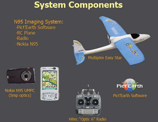
PictEarthUSA uses Google Earth Back at the beginning of the year, I wrote about a video someone posted showing a guy flying a remote controlled plane (Unmanned Aerial Vehicle or UAV) and used a digital camera to take aerial photos and show them in Google Earth. The guy who created it is David Riallant, and his company Pict'Earth is located in France. He has now expanded his operation and has a new office in the USA, which is being run by Jeffery Johnson and Stewart Long. They have a new web site called PictEarthUSA.com. The new company has a system available which uses a basic remote controlled plane, Pict'Earth software, and a Nokia N95 as both the camera system and wireless broadband communicator. They offer both live and professional aerial image processing services. Not ony that, but they have recruited the efforts of the well-known Google Earth innovator Valery Hrosunov in Perm, Russia to develop the software for the image processing and display in GE.

N95 blog
Quote:
Create your personal Google Earth: Make the Nokia N95 FLY!
You might have noticed that with Google Earth you can only zoom to a certain level, or that some parts of the world are not covered with high resolution pictures…
Your Nokia N95 can bring the solution to get a high quality bird’s eye view of the area you prefer.
All you need is your N95, a remote controlled plane, a radio and Pict’Earth Software:
Pict’Earth is a combination of advanced image acquisition components : lightweight, easy to use UAV, GPS, high resolution sensor, live communication and Pict’Earth software. Live video and GPS data are streamed, processed and displayed in real time, providing a unique opportunity to update your area of interest with fresh and sharp ultra-high resolution images. Now featuring the Nokia N95, Pict’Earth offers a low-cost, compact and integrated technical solution for the acquisition of ultra-high resolution aerial imagery.
Taking Google Earth a step further
Take Pict’Earth anywhere with you as it fits in your car trunk and is ready to use in less than 10 minutes. Take full advantage of Google Earth’s navigation functionalities and include your own sharp and up to date images to meet your professionnal and recreational needs.
Share your Live Update Experience
Pict-Earth Live processing software displays updated images in real time in Google Earth but also gives you the opportunity to stream this update to any remote authorized Google Earth user. Advanced surveys often require multiple field trips to capture, process, share and deliver information.
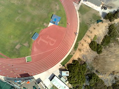
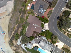
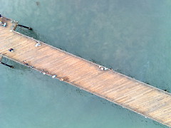
Not getting the picture yet what this is all about? Take a look at the ingredients and the results:
Now I do not know how this will be related to laws on privacy and stuff, but it sure does generate some quality results!
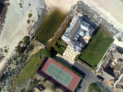
San Diego, California, USA
Solana Beach, California, USA
Oceanside, California, USA
Carlsbad, California, USA
Great initiative and for a lot of professions (real estate, corporate, construction, residential, civic, emergency/security monitoring, infrastructure and planning, golfcourses etc), this might be a very welcome solution to putting things, literally, in perspective.
Find more pictures and information over at http://www.pictearthusa.com/
tagged with: [google earth, gps, n95, n95blog, nokia, nseries, panorama]
Popularity: 74%
Ed Parsons
Quote:
The next step in Open Geodata ?
Projects like OpenStreetMap have proved that it is possible to replicate professional ground survey using low cost consumer grade GPS to create vector data sets that have the potential to complete with commercial datasets. Today I came across a website which describes a technology that could do the same for aerial imagery. Pict’Earth describe combining low cost devices which many of us already have to develop a very low cost real time aerial surveillance platform.
Using a Nokia N95, Imagery and positional information is captured and sent to the ground live during flight on a low cost model aircraft and displayed in Google Earth in near real-time. This imagery can be shared via the web with any internet connected google earth client, anywhere in the world.
Alternatively the same information can be post-processed to produce geo-referenced photo mosaics.
This is just amazing !! Ok so its not orthophotography, but then for most applications that’s not needed, key other than some good software, is the use of the N95, a 5 megapixel camera, a commuincation device and a GPS is a small cheap package - and you thought it was a phone !
Subscribe to:
Posts (Atom)