3/30/2009

Team of Russian developers ready to participate in the development of software. Complicated tasks solved with ease...

Our experience is in development of Google Geo-spatial applications (e.g. Google Earth, Google Maps, KML):
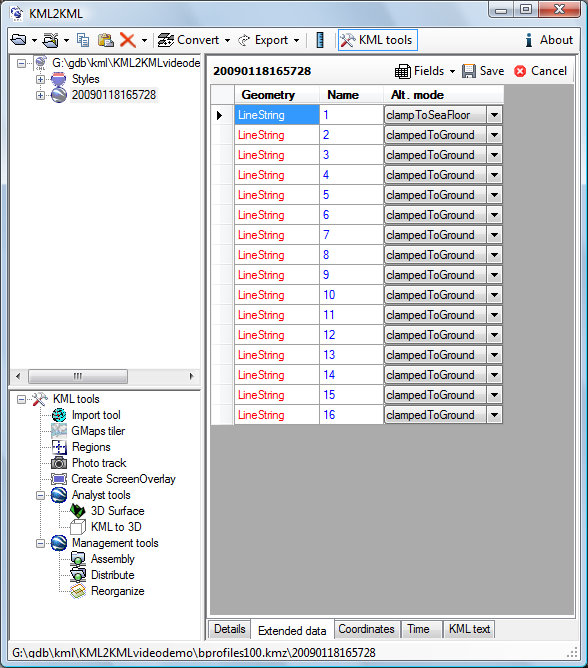
Desktop (MS .Net) stand alone (Superoverlay, KML2KML ... ) applications (see http://www.geoblogspot.com/ for details) as well as the
Web2 (Google App Engine, AJAX, Django, Python, Php) applications (see http://www.geoblogspot.com/#TOC-Web-services, http://mapwiki.geoblogspot.com)

We also have developed ArcGIS (ESRI) extensions:
ArcGIS Desktop (MS Net) extensions such as KMLer, Typeconvert, Geoselect, Isoliner, Slice3D http://www.geoblogspot.com/

In addition we also have developed custom applications (Net, Nokia smartphones) such as Pict Earth system http://pictearthusa.com/

Check out our latests news
http://blog.geoblogspot.com/ - en
http://news.eastgeology.com/ - ru

3/29/2009

Recommendation

http://www.geoblogspot.com/recommendation

To Whom It May Concern:

I am writing to recommend Valery Hronusov as an expert in developer Google Maps, Earth, and KML applications. I've worked with Valery over the last two years, and he has shown a phenomenal ability to develop key geographic applications. His work on SuperOverlay, KML2KML and other applications has been a great benefit to Geo developers world wide, and I always recommend them to developers working with our products. Valery is one of the worlds great experts on KML in particular, and has helped us push Google Earth to be better by his deep understanding of KML and his thoughtful suggestions. If you are considering anyone to help out on any geo related project, I would recommend Valery be that person.
Mano Marks
Geo Developer Advocate
Google, Inc.
http://code.google.com/more/#products-geo-earth


HronusovRecommendation

3/10/2009

Navigator 1.0.10

Navigator 1.0.10 in release.

1. Redesigned read / write settings in the ini file (corrected a problem with the installation of the units of measurement)
2. Added possibility to set the markers of objects
3. Added the ability to clear the file waypoints (mark points)

3/08/2009

KML2KML 2.7.3

With the application KML2KML, we can now build isolines, the model mixed-land-water shoreline.


Added support for new tags KML - relativeToSeaFloor, clampToSeaFloor
Now we can create models of mixed land-sea.

Open in Google Earth (requires version not below 5.0)


We can see these isolines from the water


In addition to the ocean and building a Mars isolines added service.
Our KML2KML can now build the contours and profiles to the surface of Mars. We get excellent toolbox for the comparative geology.


Examples of construction and analysis of the surface as a KML (view as GE 5):
Korolev Crater
Analysis of linear elements
Explosive breach
Newton Crater
Olimpius Mons


KMLer 2.0.12


Added support for new tags KML - relativeToSeaFloor, clampToSeaFloor
Now we can create models of mixed land-sea

Navigator 1.0.9


Navigator 1.0.9 in release
New units of measurement of distance and speed
Added a test mode. You can open the file NMEA and see the result in the GE
Presentation mode. You can save track as NMEA file and play in Navigator