Navigator demo
10/29/2008
10/25/2008
Navigator 1.0.5, Placemarker 0.0.7
New versions Navigator and Placemarker
Navigator

New features:

Proximity alarms. Checks proximity of routes, waypoints, regions and creates sounds depending on the distance.

Parameters window. Option "Fly to current position" is added.
Placemarker
Border around pictures is added
Navigator
New features:
Proximity alarms. Checks proximity of routes, waypoints, regions and creates sounds depending on the distance.
Parameters window. Option "Fly to current position" is added.
Placemarker
Border around pictures is added
10/22/2008
10/21/2008
Salt and Oil deposits.
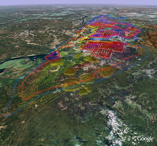
Overview
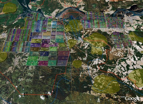
Blocks
Salt contour
 View in Google Earth
Oil contours
View in Google EarthIsolines of salt surface
View in Google EarthDrills
View in Google EarthAreas of mining
View in Google EarthBlocks
BKRU-1 (now water)
View in Google EarthBKRU-2
View in Google EarthBKRU-4
View in Google EarthSKRU-1
View in Google EarthSKRU-2
View in Google EarthSKRU-3
View in Google EarthAll datasets (assebly)
View in Google Earth
10/20/2008
KML2KML v2.6.10.0

10/14/2008
Eastgeology in release

New company Eastgeology - Востокгеология is started
Our mission
Service geological survey company
Site ВостокгеологияBlog Блог
Geology
- Conducting geological survey works (complete cycle);
- Geological engineering searches;
- Interactive forecast- search simulation;
- Service care of the mining enterprises.
Geo-information theory and the creation of software
- Program and information support of all carried out projects at all stages;
- Creation of subject software;
- Creation of subject GIS of projects and interactive electronic reports.
Design concept
- Optimization of the financial and temporary expenditures of [nedropolzovateley] for the stage of conducting [GRR].
- It is achieved on the basis of the new technologies in [GRR] (technological breakthrough), which makes it possible with the much larger effectiveness to localize the promising sections of searches still on the preliminary stage.
- The system of technologies makes it possible to exclude finalizing by expensive boring “empty” areas (ineffective or little effective boring on the standard search network).
- Under the contemporary conditions the proposed way can be considered as only output from the created crisis in the mining branch.
- On the basis of the new technologies possible to reduce financial and temporary expenditures for stage [GRR] to the orders.
Technologies of the realization
- Creation of interactive forecast- search model on the basis of the new technologies of the use of remote and analytical methods.
- Forming of the individual complex of search criteria according to the types mineral on basis selected standard objects.
- Localization of the promising objects
- Development of promising sections and their ranking on the complex of search criteria by way of the priority of setting works.
- Address designing [GRR] with the subsequent transfer of object to [nedropolzovatelyu].
Potential
Team of the specialists of high qualification. Have on their calculation a number of the successfully realized projects in reconnaissance geology and contiguous regions - economy, programming, design, both in the territory of Russia and abroad, including:- Geological survey works on diamonds, gold, platinum (radical and alluvial), chromium ores, manganic ores, the Titan-[tsirkonievye] of scattering, gabbro-dolerite and other projects;
- Creation and the maintenance specialized software (author's) in the context of the problems of geological survey, operational reconnaissance and adjacent directions - in the territory RF and abroad.
10/08/2008
Area Kama. Russian geonames
Area Kama. Russian geonames.
Region based KML.
Cities, towns. Areas+Names.
Network links. (10Mb > 40000 objects)
View in Google Earth
Rivers (>50000 Names)
Large rivers
View in Google Earth
Small rivers
View in Google Earth
We use our software:
http://kml2kml.geoblogspot.com/
http://kmler.geoblogspot.com/
Region based KML.
Cities, towns. Areas+Names.
Network links. (10Mb > 40000 objects)
View in Google EarthRivers (>50000 Names)
Large rivers
View in Google EarthSmall rivers
View in Google EarthWe use our software:
http://kml2kml.geoblogspot.com/
http://kmler.geoblogspot.com/
10/03/2008
Placemarker 0.0.6


New version
Linear gradient and hatch stules is added
Background color and style is added
Text, effect, background opacity is added
Linear gradient


Placemarker is free
Home page
Download
Example
View in Google Earth
Subscribe to:
Comments (Atom)