Today i have ArcGIS 9.3 for testing.
All our extensions see ok.
I go to reinstall ArcGIS only and results is ok.
KMLer
TypeConvert
Geoselect
Isoliner
Slice 3D
Our extensions is automatically added. This not need reinstall.
9/12/2008


9/11/2008
Geoblogspot. KMLer gallery.
Geoblogspot. KMLer gallery.
New dataset
New dataset
All countries:
 Boundaries Colorized Countries as areas
All admins level 1:
Boundaries Colorized Admins as areas
U.S. State Boundaries admins level 0,1,2:
International Coastline Shoreline
U.S. County Boundaries U.S. County colorized Puerto Rico County colorized Hawaii County colorized Alaska County colorized
U.S. National Atlas Urbanized Areas
U.S. 109th Congressional Districts
9/08/2008
Geoblogspot sites in release
http://geoblogspot.com/
New home page.
Application list.
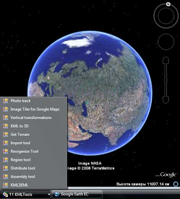

Download
Buy It

New home page.
Application list.
Stand alone applications
KML2KML
KML2KML is an application including tools for reorganization and optimization of your kml/kmz data. ($) GE Sky mode is supported.Superoverlay
Superoverlay is a stand-alone Google Earth application for tiling raster datasets and creating view based regions in KML or KMZ groundoverlay files ($) GE Sky mode is supported.S3 explorer
S3 explorer is a stand-alone application for of files operations in Amazon S3 service (FREE).ArcGIS extensions
KMLer
KMLer Professional work with Google Earth from ArcGIS ($ and FREE functions)TypeConvert
TypeConvert Convert one feature class type to another (FREE)Geoselect
Geoselect collects data sources of the current active project to one folder in the specified format, adapts the project (mxd) to the new data, checks of duplicates, projects all layers to uniform coordinate system of the project (reproject) and preserves relative paths ($)Isoliner
Isoliner make grids and points theme with interpolate by Kriging's, triangulation and density methods ($ and FREE functions)Slice 3D
Slice 3D create of slices by an arbitrary profile line. Slice 3D is intended for making of information geological-geophysical model of a rock mass ($ and FREE functions)Download
Buy It
Geoprocessing enhanced model
Note
All extensions work with ArcGIS 9.1 and 9.2 version and use Net 2.0. Additional info about deployment see on Deployment and requirementsUnsupported
Argos tools (unsupported)
Web services
Spreadsheets - Spreadsheets KML solutions
Unsupported services
Mapwiki - gadget
MapWiki2 - geocommunity
9/06/2008
World Kimberlites Database

 View in Google Earth
CITATION: Faure, S. 2006. World Kimberlites CONSOREM Database Version 2006-2. Consortium de Recherche en Exploration Minérale CONSOREM, Université du Québec à Montréal, Numerical Database on www.consorem.ca. NOTE: This publicly available database results of a compilation of other public databases, scientific and governmental publications and maps, and various data from exploration companies reports or Web sites. If you notice errors, have additional kimberlite localizations that should be included in this database, or have any comments and suggestions, please contact the author specifying the ID of the kimberlite: faure.stephane@uqam.ca
http://www.consorem.ca/index_a.html
9/05/2008
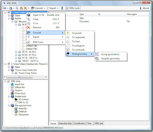
KML2KML v2.6.6.0
 KML2KML |
| License | Standard | Plus | Pro |
| Import (except shp) | x | x | x |
| Import (include shp) | | x | x |
| GMaps Tiler | x | x | x |
| Regions | x | x | x |
| Assembly | x | x | x |
| Distribute | x | x | x |
| Reorganize | x | x | x |
| Photo track | | x | x |
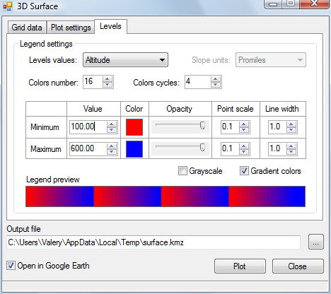
| 3D Surface | | x | x |
| KML to 3D | | x | x |
| Superoverlay PRO | | | x |
Geoblogspot news
Sites
List of applications
Stand alone applications
KML2KMLSuperoverlay
S3 explorer
ArcGIS extensions
KMLer
Geoselect
Typeconvert
Isoliner
Slice 3D
Subscribe to:
Posts (Atom)