Geological slices in GE. Example.
More info (ru) ...
Open in Google Earth
Preview
12/12/2009
9/05/2009

7/24/2009
Superoverlay 3.0.2 in release
Superoverlay 3.0.2 in release  |
| Альбом: superoverlay |

version 3.0.0
- KMZ/KML bug fixes
- Preparing for "QuadLatLon" interface
version 3.0.1
-Enhanced LOD settings
version 3.0.2
-Enhanced LOD settings for folders
See also results
7/23/2009
7/19/2009
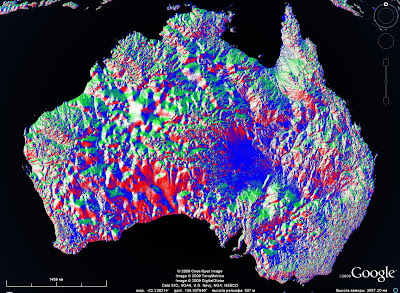
Aster 30m DEM now in Superoverlay
 |
| Альбом: superoverlay |
Aster 30m DEM now in Superoverlay
Download KML
DEM: Elevation, slope, aspect (resolution = 30m)
Ural region
Generated by Superoverlay and KML2KML http://geoblogspot.com/
7/17/2009
Map in Action. Next updates
Measure is added (line, circle, polygon)
De Beers measure
Perm measure
Admin area (enterprise level) is updated
%2017.07.2009%2034737.jpg)
Example:
Open
%2017.07.2009%2033526.jpg) |
| Альбом: Map in Action |
De Beers measure
 |
| Альбом: Map in Action |
Admin area (enterprise level) is updated
Example:
Open
7/14/2009
SRTM 90m in superoverlay Ver 2
 |
| See also: superoverlay |
SRTM 90m Digital Elevation Data V4
Elevation, slope, aspect
Ural and Kama river
Elevation, slope, aspect
Ural and Kama river
Generated by Superoverlay and KML2KML http://geoblogspot.com/
Credits: http://srtm.csi.cgiar.org/index.asp
Credits: http://srtm.csi.cgiar.org/index.asp
Gtopo30 superoverlay ver 2
 |
| See also: superoverlay |
Elevation, Slope, Aspect and Legends.
Global coverage.
Download KML gtopo30n90.kmz
Generated by Superoverlay, KML2KML http://geoblogspot.com/
Credits http://eros.usgs.gov/products/elevation/gtopo30/gtopo30.html
Download KML gtopo30n90.kmz
Generated by Superoverlay, KML2KML http://geoblogspot.com/
Credits http://eros.usgs.gov/products/elevation/gtopo30/gtopo30.html
6/19/2009
Gtopo30 superoverlay
 |
| Альбом: superoverlay |
Download KML gtopo30n90.kmz
Elevation, slope, aspect
e20,60,100,140 - n90
Generated by Superoverlay, KML2KML http://geoblogspot.com/
Credits http://eros.usgs.gov/products/elevation/gtopo30/gtopo30.html
e20,60,100,140 - n90
Generated by Superoverlay, KML2KML http://geoblogspot.com/
Credits http://eros.usgs.gov/products/elevation/gtopo30/gtopo30.html
6/18/2009
SRTM in superoverlay (90m)
 |
| Альбом: superoverlay |
SRTM 90m Digital Elevation Data V4
Elevation, slope, aspect
Ural and Kama river
Elevation, slope, aspect
Ural and Kama river
Generated by Superoverlay and KML2KML http://geoblogspot.com/
Credits: http://srtm.csi.cgiar.org/index.asp
Credits: http://srtm.csi.cgiar.org/index.asp
6/11/2009
SRTM in superoverlay (NC 150m)

Download KML
Credits http://srtmkml.googlepages.com/ Now part of the data does not open, and i decided to create a new tiles by Superoverlay
6/05/2009
Map in Action is updated
Map in Action is updated
New features:
- Streetview is supported
GMaps standard and Openstreetmap coverages now supported
New features:
- Streetview is supported
%2005.06.2009%2030842.jpg) |
| Альбом: Map in Action |
GMaps standard and Openstreetmap coverages now supported
6/03/2009
KMLer 2.0.15
KMLer 2.0.15 in release
New features:
Export to KML - KML 2.2 and GMaps GeoXml standards is supported
Open
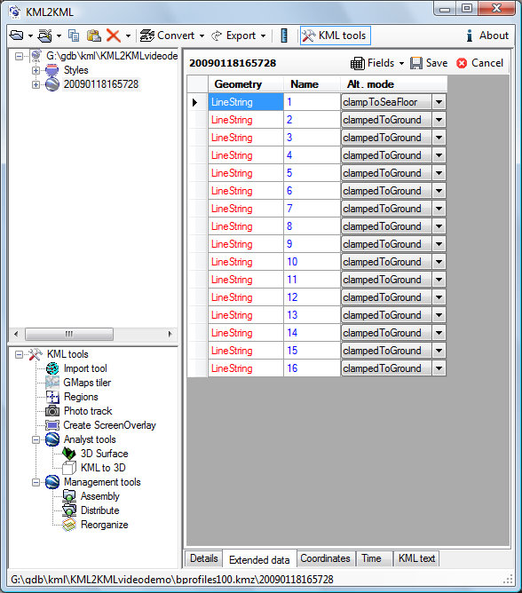
KML2KML 2.7.11
KML2KML 2.7.11 in release
New feature: Capture (grayscale) current Google Earth view
Rotation and LatLonQuad is supported (see KML docs also)
Allows non-rectangular quadrilateral ground overlays. Specifies the coordinates of the four corner points of a quadrilateral defining the overlay area.
New feature: Capture (grayscale) current Google Earth view
Rotation and LatLonQuad is supported (see KML docs also)
 |
| Альбом: KML2KML 266 |
Copy Source | Copy HTML- <?xml version="1.0" encoding="utf-8" ?>
- - <kml xmlns="http://www.opengis.net/kml/2.2">
- - <GroundOverlay>
- - <Icon>
- <href>u1.jpg</href>
- <viewBoundScale>0.75</viewBoundScale>
- </Icon>
- - <gx:LatLonQuad xmlns:gx="http://www.google.com/kml/ext/2.2">
- <coordinates>55.2330205227194,57.8050219267041 56.6850994299952,57.3591335881169 57.4307212872883,58.0290400213456 55.9662727901691,58.4844650685378</coordinates>
- </gx:LatLonQuad>
- </GroundOverlay>
- </kml>
5/25/2009
Map in Action. Rich editor
Map in action use for now rich/html editor.
http://mapinaction.appspot.com/info?t=K&K=agttYXBpbmFjdGlvbnIOCxIGUmVjb3JkGJThAQw - open as KML
%2025.05.2009%20165841.jpg) |
| Альбом: Map in Action |
%2025.05.2009%20165930.jpg) |
| Альбом: Map in Action |
http://mapinaction.appspot.com/Event.html?k=agttYXBpbmFjdGlvbnIOCxIGUmVjb3JkGJThAQw - open as publication
5/22/2009


Map in Action. UI is updated
%2022.05.2009%2010444.jpg) |
| Альбом: Map in Action |
New User interface
Roadmap and base coverages (satellite, maps, terrain + opacity) is added
5/19/2009
%2019.05.2009%2004635.jpg)
5/10/2009
Map in Action
Open
Widget
Gadget
For GPS http://mapinaction.appspot.com/info?t=G&MP=agttYXBpbmFjdGlvbnILCxIEQ2l0eRj1Ugw&e=AC|PR|OT
Copy Source | Copy HTML
<iframe width="600" height="400" frameborder="0" scrolling="no" marginheight="0" marginwidth="0" src="http://mapinaction.appspot.com/MainMap.html?MP=agttYXBpbmFjdGlvbnILCxIEQ2l0eRj1Ugw"></iframe><br /><small><a href="http://mapinaction.appspot.com/MainMap.html?MP=agttYXBpbmFjdGlvbnILCxIEQ2l0eRj1Ugw" style="color:#0000FF;text-align:left">Open</a></small>
Gadget
Copy Source | Copy HTML
<Module>
<!-- You can modify this file to customize your gadget information. -->

  <ModulePrefs title="Maps storage"
               title_url="http://www.eastgeology.com/"
               height="560"
               width="860"
               author="Valery Hronusov, Serge Devyatkov"
               author_email="xbbster@gmail.com"
               screenshot="http://sites.google.com/a/eastgeology.com/public/_/rsrc/1223489575979/config/app/images/customLogo/customLogo.gif?revision=5"
               thumbnail="http://sites.google.com/a/eastgeology.com/public/_/rsrc/1223489575979/config/app/images/customLogo/customLogo.gif?revision=5">
     <Require feature="opensocial-0.7"/>
  </ModulePrefs>
  <Content type="url" href="http://mapinaction.appspot.com/MainMap.html?MP=agttYXBpbmFjdGlvbnILCxIEQ2l0eRj1Ugw"/>
</Module>
For GPS http://mapinaction.appspot.com/info?t=G&MP=agttYXBpbmFjdGlvbnILCxIEQ2l0eRj1Ugw&e=AC|PR|OT
5/06/2009
KML2KML 2.7.9
KML2KML 2.7.9 in release
Export to shp is updated. Extended data to shp attributes is supported.
Points arrangement is updated.
Export to shp is updated. Extended data to shp attributes is supported.
Points arrangement is updated.
4/17/2009
KMLer 2.0.13

KMLer 2.0.13 in release
New features:
- Attribute "None" is added
- Legend is added
Download KML example - South America soil lithology
4/07/2009
KML2KML 2.7.6
KML2KML 2.7.6 in release
New features - Image Tiler tools
Embed code:
New features - Image Tiler tools
One database of images for the GE and GMaps
Rotation in Image tiler is supported.
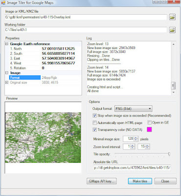
Example
http://dl.getdropbox.com/u/470962/kml/tiles/o40-115/CustomTiling.html - GMaps
http://dl.getdropbox.com/u/470962/kml/tiles/o40-115/o40-115.kml - KML
http://dl.getdropbox.com/u/470962/kml/tiles/o40-115/o40-115.kml - KML
Info added to corporate map http://mapinaction.appspot.com/ - check tags, press refresh and see Tile Layer O40-115
Embed code:
Copy Source | Copy HTML
<iframe width='700' height='700' frameborder='0' src='http://dl.getdropbox.com/u/470962/kml/tiles/o40-115/CustomTiling.html'></iframe>
3/30/2009
Team of Russian developers ready to participate in the development of software. Complicated tasks solved with ease...
Our experience is in development of Google Geo-spatial applications (e.g. Google Earth, Google Maps, KML):
Desktop (MS .Net) stand alone (Superoverlay, KML2KML ... ) applications (see http://www.geoblogspot.com/ for details) as well as the
Web2 (Google App Engine, AJAX, Django, Python, Php) applications (see http://www.geoblogspot.com/#TOC-Web-services, http://mapwiki.geoblogspot.com)
We also have developed ArcGIS (ESRI) extensions:
ArcGIS Desktop (MS Net) extensions such as KMLer, Typeconvert, Geoselect, Isoliner, Slice3D http://www.geoblogspot.com/
In addition we also have developed custom applications (Net, Nokia smartphones) such as Pict Earth system http://pictearthusa.com/
Check out our latests news
http://blog.geoblogspot.com/ - en
http://news.eastgeology.com/ - ru
3/29/2009
Recommendation
http://www.geoblogspot.com/recommendation
To Whom It May Concern:
I am writing to recommend Valery Hronusov as an expert in developer Google Maps, Earth, and KML applications. I've worked with Valery over the last two years, and he has shown a phenomenal ability to develop key geographic applications. His work on SuperOverlay, KML2KML and other applications has been a great benefit to Geo developers world wide, and I always recommend them to developers working with our products. Valery is one of the worlds great experts on KML in particular, and has helped us push Google Earth to be better by his deep understanding of KML and his thoughtful suggestions. If you are considering anyone to help out on any geo related project, I would recommend Valery be that person.
HronusovRecommendation
To Whom It May Concern:
I am writing to recommend Valery Hronusov as an expert in developer Google Maps, Earth, and KML applications. I've worked with Valery over the last two years, and he has shown a phenomenal ability to develop key geographic applications. His work on SuperOverlay, KML2KML and other applications has been a great benefit to Geo developers world wide, and I always recommend them to developers working with our products. Valery is one of the worlds great experts on KML in particular, and has helped us push Google Earth to be better by his deep understanding of KML and his thoughtful suggestions. If you are considering anyone to help out on any geo related project, I would recommend Valery be that person.
Mano Marks
Geo Developer Advocate
Google, Inc.
http://code.google.com/more/#products-geo-earth
Geo Developer Advocate
Google, Inc.
http://code.google.com/more/#products-geo-earth
HronusovRecommendation
3/10/2009
Navigator 1.0.10
Navigator 1.0.10 in release.
1. Redesigned read / write settings in the ini file (corrected a problem with the installation of the units of measurement)
2. Added possibility to set the markers of objects
3. Added the ability to clear the file waypoints (mark points)
1. Redesigned read / write settings in the ini file (corrected a problem with the installation of the units of measurement)
2. Added possibility to set the markers of objects
3. Added the ability to clear the file waypoints (mark points)
3/08/2009
KML2KML 2.7.3
With the application KML2KML, we can now build isolines, the model mixed-land-water shoreline.

We can see these isolines from the water
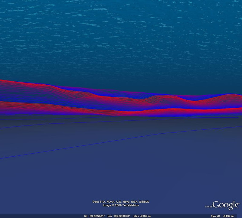


Added support for new tags KML - relativeToSeaFloor, clampToSeaFloor
Now we can create models of mixed land-sea.
Open in Google Earth (requires version not below 5.0)
Now we can create models of mixed land-sea.
Open in Google Earth (requires version not below 5.0)
We can see these isolines from the water
In addition to the ocean and building a Mars isolines added service.
Our KML2KML can now build the contours and profiles to the surface of Mars. We get excellent toolbox for the comparative geology.
Our KML2KML can now build the contours and profiles to the surface of Mars. We get excellent toolbox for the comparative geology.


Examples of construction and analysis of the surface as a KML (view as GE 5):
Korolev Crater
Analysis of linear elements
Explosive breach
Newton Crater
Olimpius Mons
Korolev Crater
Analysis of linear elements
Explosive breach
Newton Crater
Olimpius Mons
KMLer 2.0.12

Added support for new tags KML - relativeToSeaFloor, clampToSeaFloor
Now we can create models of mixed land-sea
Now we can create models of mixed land-sea
Navigator 1.0.9

Navigator 1.0.9 in release
New units of measurement of distance and speed
Added a test mode. You can open the file NMEA and see the result in the GE
New units of measurement of distance and speed
Added a test mode. You can open the file NMEA and see the result in the GE
Presentation mode. You can save track as NMEA file and play in Navigator
2/22/2009
GE Scribd
http://www.scribd.com
Cool service for all doc types.
Nice embed pdf feature.
In GE AOI and time of works is added. See pdf in description.

Cool service for all doc types.
Nice embed pdf feature.
In GE AOI and time of works is added. See pdf in description.
Attachments
GeoScribd.kmz
Pdf - our report-manual
geoconstructor
2/13/2009
KML to HTML.
Great service for KML publication - http://s-c.me/
1. Open GE
2. Select placemark, copy to clipboard
3. Open http://s-c.me/ and paste KML
4. Select XML, press button HighLightIt!
5. Copy HTML
6. Make New post in Blog, select HTML mode
7. Paste HTML
8. See result, public, enjoy!
9. Select KML in blog text, copy to clipboard
10. Paste in GE My Places, enjoy two :)
Copy Source | Copy HTML
<?xml version="1.0" encoding="UTF-8"?>
<kml xmlns="http://www.opengis.net/kml/2.2" xmlns:gx="http://www.google.com/kml/ext/2.2" xmlns:kml="http://www.opengis.net/kml/2.2" xmlns:atom="http://www.w3.org/2005/Atom">
<Placemark>
    <name>Sutro Baths in 1946</name>
    <visibility>0</visibility>
    <Camera>
        <gx:TimeStamp><when>1946-07-29T05:00:00-08:00</when>
</gx:TimeStamp>
        <longitude>-122.518172</longitude>
        <latitude>37.778036</latitude>
        <altitude>221</altitude>
        <heading>70</heading>
        <tilt>75</tilt>
        <roll>0</roll>
    </Camera>
</Placemark>
</kml>
Subscribe to:
Posts (Atom)