


New features of Isoliner and KMLer we can use by Google Earth publications.
See Chernobyl ver 3 Post in BBS
KMZ files:
Lines
Polygons
Track points
Track lines
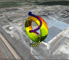
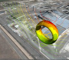
Vertical isolines
See also
Chernobyl v.2
Chernobyl v.1
Gallery of images
Credits:
1. Krasnov V.A. Head of nuclear and radioecology part
2. Panasyuk M. I. Head of the sector of geoecological investigations, candidate of technical sciences
3. Pidberesniy S. S. Head of radioecology group
4. Skorbun A. D. Major scientific worker, candidate of sciences in physics and mathematics
5. Alfyorov A. M. Scientific worker
6. Orujiy A. P. Leading engineer
7. Levin G. V. engineer-geophysics of 1-th category
8. Scherbin V. M. Deputy director, candidate of sciences in physics and mathematics
9. Kanchenko V. A. Head of department, doctor of technical sciences
10. Klyuchnykov O.O., doctor of technical sciences, director ISP NPP.
USE OF GIS-TECHNOLOGIES FOR FORECASTING OF RADIOACTIVE WASTES QUANTITIES IN SOILS ON THE INDUSTRIAL SITE AROUND DESTROYED 4-TH UNIT OF CHORNOBYL NPP
Institute for Safety Problems of Nuclear Power Plants
No comments:
Post a Comment