KML2KML is an application including tools for reorganization and optimization of your kml/kmz data.
New examples of results:
All Aircraft in Flight. Region Based KML.
 View in Google Earth
Classic version of this collection you can see in BBS
Google Earth Cemeteries. Region Based KML.
View in Google EarthThis example of KML2KML based on great job by Phil Verney
http://bbs.keyhole.com/ubb/z0302a1700/Google_Earth_Cemeteries.kmz
My job:
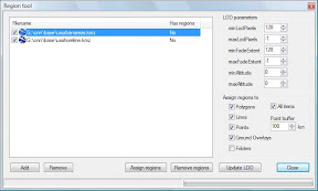
1. Open Region Tool
2. Open "High level" and set
Points buffer= 300km
Minlodpixel=256
Maxlodpixel=1024
3. Press Assign Regions
4. Uncheck "Higth level"
5. Open "Low level" and set
Points buffer= 300km
Minlodpixel=1024
Maxlodpixel=-1
By double click on KML in list we can see results in GE.
No comments:
Post a Comment