Putting Blend 4, Visual Studio 2010 and ESRI ArcGIS Web Mapping in a working system. To view the maps, you must install SilverLight 4. On clicking the right mouse button on the map, we can install it as a local application. After installation, when re-click the right button, we can remove the application
Showing posts with label gis. Show all posts
Showing posts with label gis. Show all posts


3/30/2009
Team of Russian developers ready to participate in the development of software. Complicated tasks solved with ease...
Our experience is in development of Google Geo-spatial applications (e.g. Google Earth, Google Maps, KML):
Desktop (MS .Net) stand alone (Superoverlay, KML2KML ... ) applications (see http://www.geoblogspot.com/ for details) as well as the
Web2 (Google App Engine, AJAX, Django, Python, Php) applications (see http://www.geoblogspot.com/#TOC-Web-services, http://mapwiki.geoblogspot.com)
We also have developed ArcGIS (ESRI) extensions:
ArcGIS Desktop (MS Net) extensions such as KMLer, Typeconvert, Geoselect, Isoliner, Slice3D http://www.geoblogspot.com/
In addition we also have developed custom applications (Net, Nokia smartphones) such as Pict Earth system http://pictearthusa.com/
Check out our latests news
http://blog.geoblogspot.com/ - en
http://news.eastgeology.com/ - ru
5/03/2008
Neogeography in Russia


First Russian neogeography conference:
http://www.engl.vt21.ru/index.php
http://rnd.cnews.ru/reviews/index_science.shtml?2008/04/30/299212_2
2/22/2008
Russian Geoblog is released
Russian geoblog (геоблог) is released.
Example of geological publication
Full text
Идея блога - создать электронный журнал, посвященный проблемам геоинформатики и естественных наук.
С нашей стороны здесь попытка решить несколько задач:
1. Использовать наиболее современные методы создания и систематизации публикаций
2. Помочь освоить эти методы специалистам
3. Создать возможность специалистам публиковать свои результаты в компактные сроки и на хорошем уровне
Example of geological publication
Full text
Идея блога - создать электронный журнал, посвященный проблемам геоинформатики и естественных наук.
С нашей стороны здесь попытка решить несколько задач:
1. Использовать наиболее современные методы создания и систематизации публикаций
2. Помочь освоить эти методы специалистам
3. Создать возможность специалистам публиковать свои результаты в компактные сроки и на хорошем уровне
2/19/2007
Individual price
All commercial software have now individual price.
------------------
Superoverlay
Download
Trial version( 7 days ) and/or update.
Unzip and run Superoverlay.msi
Buy It
Standard individual price
Number of licenses 1-9 USD: 20.00
Number of licenses From10 USD: 15.00
Plus individual price
Number of licenses 1-1 USD: 35.00
Number of licenses 2-4 USD: 30.00
Number of licenses 5-9 USD: 25.00
Number of licenses From10 USD: 20.00
Pro individual price
Number of licenses 1-1 USD: 90.00
Number of licenses 2-4 USD: 80.00
Number of licenses 5-9 USD: 70.00
Number of licenses From10 USD: 60.00
------------------
KMLer
Download:
Current version - Net 2.0, ArcGIS 9.1 and ArcGIS 9.2
Prev version - Net 1.1
Old version - Net 1.1, ArcGIS 9.0 (SP3)
Buy It
Standard individual price
Number of licenses 1-9 USD: 20.00
Number of licenses From10 USD: 15.00
Plus individual price
Number of licenses 1-1 USD: 35.00
Number of licenses 2-4 USD: 30.00
Number of licenses 5-9 USD: 25.00
Number of licenses From10 USD: 20.00
Pro individual price
Number of licenses 1-1 USD: 50.00
Number of licenses 2-4 USD: 45.00
Number of licenses 5-9 USD: 40.00
Number of licenses From10 USD: 35.00
------------------
Geoselect
Download:
Current version - Net 2.0, ArcGIS 9.1 and ArcGIS 9.2
Prev version - Net 1.1
Buy It
Individual priceNumber of licenses 1-1 USD: 95.00
Number of licenses 2-4 USD: 75.00
Number of licenses 5-9 USD: 60.00
Number of licenses From10 USD: 50.00
------------------
Isoliner
Download:
Current version - Net 2.0, ArcGIS 9.1 and ArcGIS 9.2
Prev version - Net 1.1
Old version - Net 1.1, ArcGIS 9.0 (SP3)
Plus individual price
Number of licenses 1-1 USD: 50.00
Number of licenses 2-4 USD: 45.00
Number of licenses 5-9 USD: 40.00
Number of licenses From10 USD: 35.00
Pro individual price
Number of licenses 1-1 USD: 150.00
Number of licenses 2-4 USD: 120.00
Number of licenses 5-9 USD: 100.00
Number of licenses From10 USD: 75.00
------------------
Slice 3D
Download:Current version - Net 2.0, ArcGIS 9.1 and ArcGIS 9.2
Prev version - Net 1.1
Buy It
LT individual price
Number of licenses 1-1 USD: 50.00
Number of licenses 2-4 USD: 40.00
Number of licenses 5-9 USD: 30.00
Number of licenses From10 USD: 25.00
Full individual price
Number of licenses 1-1 USD: 200.00
Number of licenses 2-4 USD: 150.00
Number of licenses 5-9 USD: 100.00
Number of licenses From10 USD: 75.00
2/03/2007
GIS research. History, current, future.
My next step in practical GIS ideas in science is as follows:
- History: GIS tools have been used for maps and data generation only. Passive elements only of a person's limited interests.
- Current: GIS tools are currently an engine that can process new technologies and devices. (Active elements, not tools)
- Future: Datamining in real time including: geo-cameras and other geo-sensors, flight, and other objects in real time as multiple components of a virtual globe. Geo-Cameras can be used on any moving object (Car, Boat, plane), or can be stationary. Many diferent sources can be used to store and process trends, statistics, etc.
- History: GIS tools have been used for maps and data generation only. Passive elements only of a person's limited interests.
- Current: GIS tools are currently an engine that can process new technologies and devices. (Active elements, not tools)
- Future: Datamining in real time including: geo-cameras and other geo-sensors, flight, and other objects in real time as multiple components of a virtual globe. Geo-Cameras can be used on any moving object (Car, Boat, plane), or can be stationary. Many diferent sources can be used to store and process trends, statistics, etc.
1/30/2007
ArcGIS 9.2. Test of extensions. Day 3
We use next order of setup:
1. Remove all additional extensions ( Typeconvert , KMLer , Geoselect , Isoliner , Slice 3D )
2. Remove ArcGIS 9.1
3. Setup ArcGIS 9.2
4. Setup of KMLer and Isoliner do not have of problems. By tests of all functions we see fine results. We not see of problems by work Isoliner with rasters.
5. For Slice 3D Typeconvert and Geoselect need Net 1.1. Setup of this extensions on ArcGIS 9.2 have now problems. We think adapt this extensions to Net 2.0 in near time.
1. Remove all additional extensions ( Typeconvert , KMLer , Geoselect , Isoliner , Slice 3D )
2. Remove ArcGIS 9.1
3. Setup ArcGIS 9.2
4. Setup of KMLer and Isoliner do not have of problems. By tests of all functions we see fine results. We not see of problems by work Isoliner with rasters.
5. For Slice 3D Typeconvert and Geoselect need Net 1.1. Setup of this extensions on ArcGIS 9.2 have now problems. We think adapt this extensions to Net 2.0 in near time.
1/26/2007
Pict'Earth. News.
News from Pict'Earth blog.
Video
Image

We public and place Network link to dataset in BBS forum.
Full images collection see http://www.flickr.com/photos/valery35/sets/72157594386604591/
Example of large large image (4800 x 4182) with premium quality http://www.flickr.com/photo_zoom.gne?id=368176133&size=o
Generation of tiled images and network links we make with Superoverlay.
Video
Image
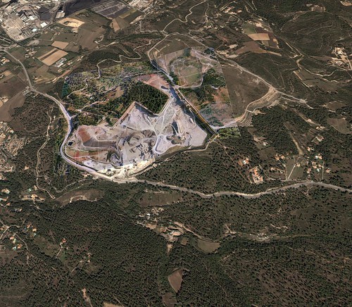
We public and place Network link to dataset in BBS forum.
Full images collection see http://www.flickr.com/photos/valery35/sets/72157594386604591/
Example of large large image (4800 x 4182) with premium quality http://www.flickr.com/photo_zoom.gne?id=368176133&size=o
Generation of tiled images and network links we make with Superoverlay.


1/22/2007
New Pict'Earth blog!

New Pict'Earth blog!
We (i and David Riallant) began now partnership.
We have ideas make professional solution on base of Pict'Earth hardware system and new Pict'Earth software system.
Images in this post it is first results of Superoverlay generation gataset by Pict'Earth.
Network link to superoverlay.
Load and double click Network link please.
1/18/2007
Isoliner 1.0.8 New structure of dialogues. Part.1
Kriging.
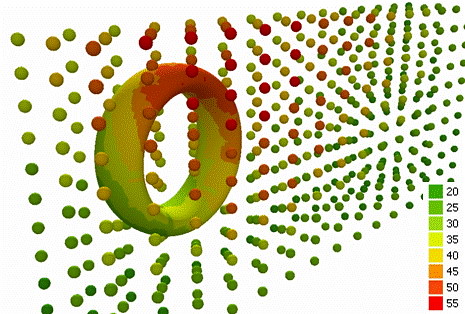
Create GRID and points feature class (mesh) by selected source layer and Z attribute.
How Kriging works.
Kriging is an advanced geostatistical procedure that generates an estimated surface from a scattered set of points with z values. Unlike the other interpolation methods, Kriging involves an interactive investigation of the spatial behavior of the phenomenon represented by the z values before the user selects the best estimation method for generating the output surface.
2D Kriging

2D Feature Kriging

3D Kriging

3D feature Kriging

3D Surface

Create GRID and points feature class (mesh) by selected source layer and Z attribute.
How Kriging works.
Kriging is an advanced geostatistical procedure that generates an estimated surface from a scattered set of points with z values. Unlike the other interpolation methods, Kriging involves an interactive investigation of the spatial behavior of the phenomenon represented by the z values before the user selects the best estimation method for generating the output surface.
2D Kriging

2D Feature Kriging

3D Kriging

3D feature Kriging

3D Surface

Isoliner 1.0.8 New structure of menu.


1/16/2007
Isoliner 1.0.7
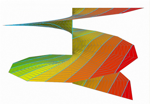
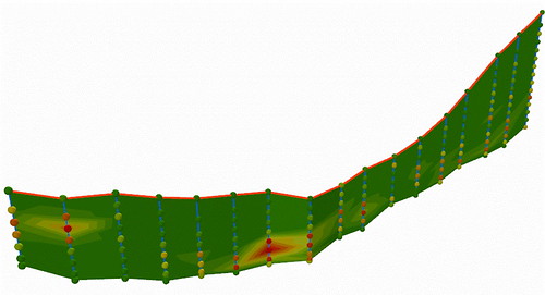

New version of Isoliner. Isoliner is the ArcGIS extension for make grids and points theme with interpolate by Kriging's and triangulation method. Isoliner include additional 3D functions, interpolation by features, generation of random points.
Full gallery of images.
Large updates. Change structure of functions and license.
2D Kriging - free
2D Feature Kriging - free
3D Kriging - plus
3D Feature Kriging - plus
Interpolation By Raster - free
Interpolation By Mesh - plus
Interpolation By Triangulation - pro
3D Surface - pro
Create Triangulation - pro
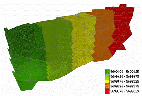
Create Section - pro
Create Section By Plane - plus
Create Section By Profile - plus
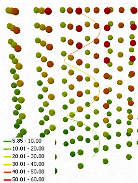
Create track - plus
Convert Objects To 3D - free
Convert Raster To Points - free
Convert Mesh To Triangulation - pro
Import Objects To Mesh - plus
Import Objects To Voxel Mesh - pro
Random Points - free
3D Random Points - free
Random Point in Ellipse - free
Price: Standard / Plus / Pro versions - USD Free / 50 / 150
1/12/2007
Superoverlay.1.5.4
Superoverlay version 1.5.4
New features:
- 'Convert to 8-bit PNG' is now available ('convert to 8 bit' algorithm is improved)
Speed of work with 8 bit images now very fast.
- 'Invert black to white' option is added (useful for inverting black background to white). You can set white color as transparency and black as white for best show of labels and grid.
Improved features:
- full import of Groundoverlay parameters by add KML ( KMZ ) - altitude, timer tags, transparency, georeference.
We adapt Superoverlay to works with standard topomaps, geological and other thematic maps. If your map have small count of colors then you can use:
- 8bit output (png)
- transparency white color for remove background
- "invert black to white" option for see labels and grid in white color.
Google Eart support transparency in PNG files. 8bit PNG files have small size and see as optimal solution for standards maps.
New features:
- 'Convert to 8-bit PNG' is now available ('convert to 8 bit' algorithm is improved)
Speed of work with 8 bit images now very fast.
- 'Invert black to white' option is added (useful for inverting black background to white). You can set white color as transparency and black as white for best show of labels and grid.
Improved features:
- full import of Groundoverlay parameters by add KML ( KMZ ) - altitude, timer tags, transparency, georeference.
We adapt Superoverlay to works with standard topomaps, geological and other thematic maps. If your map have small count of colors then you can use:
- 8bit output (png)
- transparency white color for remove background
- "invert black to white" option for see labels and grid in white color.
Google Eart support transparency in PNG files. 8bit PNG files have small size and see as optimal solution for standards maps.
1/03/2007
Ground overlay GE&GMaps solution.


We can use one images dataset for groundoverlays in GE and GMaps.
Example:
I use WGS-84 projection. For work need embed image into KMZ file.
You can open one MODIS Terra image in GE and GMaps:
Open KMZ file in GE
Open KMZ file in GMaps
We see right result.
Structure KML+ relative path to image see best. For one image we can connect from many clients (GIS and image viewers). This construction now supported by GE (see example of KML and image) and not supported by GMaps. GMaps support absolute path only. Maybe next version of GMaps can use KML+image construction with relative path.
12/31/2006
Superoverlay Pro

Very good examples of Superoverlay 1.5 Pro public Matt Fox
It is California Geologic Maps and Geologic Map of the United States by USGS
Nice professional work, good examples. Enjoy!
Google GeoCalendar :)
I test geo events and make Calendar.
You can add New calendar to your Calendars.
Now this calendar have 2 events. You can see events in GMaps by click and select in Where link Map
You can see this calendar as HTML or XML
You can see and use this with Feedburner
You can also insert into your Calendar events only. One or two.
I do not know all ways from this. It's see very interests.
You can add New calendar to your Calendars.
Now this calendar have 2 events. You can see events in GMaps by click and select in Where link Map
You can see this calendar as HTML or XML
You can see and use this with Feedburner
You can also insert into your Calendar events only. One or two.
I do not know all ways from this. It's see very interests.
11/29/2006
Spreadsheets. New site.
New spreadsheets site-presentation Editgrid KML solutions
AERONET La Jolla
Spreedsheets at calculator links and time animation. AERONET_La_Jolla. Terra. Time animation. 2006.
Pixel size: 2km, 1km, 500m, 250m.
Editgrid XML+XSL.Images group by month.
Credits:
Modis rapid response system.
Download KML: Network link
Path calculator
Spreedsheets at calculator for generation of points, segments and path. All lengths calculate by Great circle distance formula (km, mi).
Download KML : Network link
Fire maps
Spreedsheets at calculator links and time animation.
Editgrid XML+XSL.Images group by month.
Wildfire :
- small 600x300
- med 2048x1024
- large 4096x2048
- xlarge 8192x4096
Credits:
MODIS Rapid Response System Global Fire Maps
Download KML: Network link
Birds fly
Spreedsheets at calculator generate points, segments and path. Time animation. All lengths calculate by Great circle distance formula (km, mi). Generation KML for user datasets. Intergration to Googlegeo ( GE & GMaps ). Datasets and photos by Eugene Potapov.
Download KML: Network link
11/26/2006


11/24/2006
KMLer. New home page.

KMLer. New home page.
Overview
KMLer is the ArcGIS extension for professional work with Google Earth. We recommend using this module with our free Typeconvert extension.
KMLer Plus also supports additional functionality at description building.
KMLer Pro also supports additional 3d features, LOD, Fade in Google Earth.
Functionality
Quick frame export
Export to KML
Import from KML
Create overlays
Export TIN
Export screen
Import screen
Set view in GE
Get view from GE
Get points from terrain
Z-service
Shooting on route
Export screens
Import screens
Terrain points
About
Subscribe to:
Posts (Atom)