Showing posts with label video. Show all posts
Showing posts with label video. Show all posts
11/11/2008


Corporate Map. Video
Corporate Map has expanded the data.
This is the municipal boundaries of settlements and areas of the Perm region, the data from video cameras in real time, the Ministry of Trade and Enterprise, the group Neogeography(ru) A video for the demonstration of new service and training.
Russian version
This is the municipal boundaries of settlements and areas of the Perm region, the data from video cameras in real time, the Ministry of Trade and Enterprise, the group Neogeography(ru) A video for the demonstration of new service and training.
Russian version
8/14/2008
KML2KML Video

KML2KML
New version 2.6.2Features:
- embed GE
- time animation editor
- group to multigeometry
KML to 3D profile video demo
9/21/2007
Pict Earth USA missions. Video from photos. ver 2
Pict Earth USA missions. Video from photos. ver 2
Calibrated.
Calibrated.
9/20/2007
8/25/2007
GE 4.2. Photo overlay. Embed video and flash.
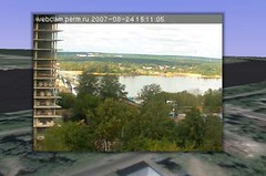
Photo overlay examples:
Webcam realtime photo overlay! Refresh every 1 sec.
NOTE! If image not autorefreshed then click right mouse on placemark in tree of placemarks and press refresh in menu.
Download KML
Gray Eagle flight academy photos
Download KML
Photos from Cessna
Download KML
Embed video in balloon. Calavera.
Download KML
Embed slide show. Encinitas Ranch. Embed ning photo album.
Download KML
8/11/2007
7/17/2007

7/16/2007
4/06/2007
2/03/2007
GIS research. History, current, future.
My next step in practical GIS ideas in science is as follows:
- History: GIS tools have been used for maps and data generation only. Passive elements only of a person's limited interests.
- Current: GIS tools are currently an engine that can process new technologies and devices. (Active elements, not tools)
- Future: Datamining in real time including: geo-cameras and other geo-sensors, flight, and other objects in real time as multiple components of a virtual globe. Geo-Cameras can be used on any moving object (Car, Boat, plane), or can be stationary. Many diferent sources can be used to store and process trends, statistics, etc.
- History: GIS tools have been used for maps and data generation only. Passive elements only of a person's limited interests.
- Current: GIS tools are currently an engine that can process new technologies and devices. (Active elements, not tools)
- Future: Datamining in real time including: geo-cameras and other geo-sensors, flight, and other objects in real time as multiple components of a virtual globe. Geo-Cameras can be used on any moving object (Car, Boat, plane), or can be stationary. Many diferent sources can be used to store and process trends, statistics, etc.
1/26/2007
Pict'Earth. News.
News from Pict'Earth blog.
Video
Image

We public and place Network link to dataset in BBS forum.
Full images collection see http://www.flickr.com/photos/valery35/sets/72157594386604591/
Example of large large image (4800 x 4182) with premium quality http://www.flickr.com/photo_zoom.gne?id=368176133&size=o
Generation of tiled images and network links we make with Superoverlay.
Video
Image
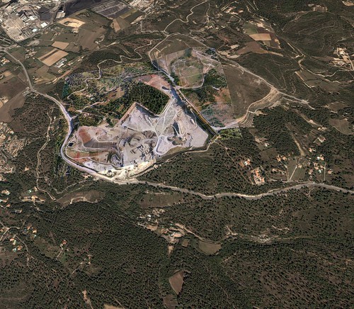
We public and place Network link to dataset in BBS forum.
Full images collection see http://www.flickr.com/photos/valery35/sets/72157594386604591/
Example of large large image (4800 x 4182) with premium quality http://www.flickr.com/photo_zoom.gne?id=368176133&size=o
Generation of tiled images and network links we make with Superoverlay.
1/22/2007
New Pict'Earth blog!

New Pict'Earth blog!
We (i and David Riallant) began now partnership.
We have ideas make professional solution on base of Pict'Earth hardware system and new Pict'Earth software system.
Images in this post it is first results of Superoverlay generation gataset by Pict'Earth.
Network link to superoverlay.
Load and double click Network link please.
Subscribe to:
Posts (Atom)