Google LatLong: How big is the Deepwater Horizon oil spill?
Crude oil from the Deepwater Horizon oil rig explosion continues to leak into the Gulf Coast. Official estimates state a rate of 200,000 gallons a day, while some private estimates think it could be over a million gallons each day. The spill covers an area of over 2,500 square miles, and shows no signs of slowing down.
Showing posts with label Maps. Show all posts
Showing posts with label Maps. Show all posts


1/24/2009
Custom World Maps generator
Create custom color map of the world. Also create color maps of Africa, Asia, Europe, Middle East and South America in png format.
Simple set colors of countries and press Update Map colors button.
Right click and save image or copy URL for using
You can insert results into your pages

Africa

Europe

7/16/2008
MapWiki v3.0 in Action
Chris Glazier, Valery Hronusov
New page http://villagegis.com/clients/syracuse/syracuse_PI.html is available.
Public input can be tracked using Google based mashups and GEmap. This page can be used by users that are "Logged In" or Anonymous Users, and data can be monitored and maintained by application administrators. The display is fast and easy to use. Events are categorized and placed by pulldown menus and custom icons. Web users can see placemarks, categorized by type and all events are assigned to a unique city domain in the database. Time animated KMLs can be generated from displayed data and sent to Google Earth. Example of a primary map (city)
Edit mode is available
This mapwiki is also available as Gadget to IPhone users and iGoogle environment. You can add this gadget into spreadsheets or pages.
Our site for testing and development http://sites.geoblogspot.com/mapwiki/
List of maps is available. You can see difference set of icons, topics. Difference languages is supported.
We can include KML feed from one map into other maps.
As example:
Utah map = North Ogden map + Salt Lake City map + Syracuse map
KML data to Utah from cities added automatically.
Example of user defined icons, language and topics you can see in Perm map (Russia)
New page http://villagegis.com/clients/syracuse/syracuse_PI.html is available.
Public input can be tracked using Google based mashups and GEmap. This page can be used by users that are "Logged In" or Anonymous Users, and data can be monitored and maintained by application administrators. The display is fast and easy to use. Events are categorized and placed by pulldown menus and custom icons. Web users can see placemarks, categorized by type and all events are assigned to a unique city domain in the database. Time animated KMLs can be generated from displayed data and sent to Google Earth.
Commuters, residents, officials, tourists, businesses, and others can add his placemarks (points, lines, polygons) along with event info. A Time stamp is automatically added and can be display in KML time-animation in Google Earth. The Map display can be changed to use Map, Satellite, Earth 3D mode functions (with GE plugin).
Mayors and City Councils can track, visualize and display information concerning community complaints, comments or concerns, with user contact information or without. Data can be retrieved via GeoRSS Feed.
Administration accounts can upload KML data as an overlay. Data from our maps also can be used as KML overlay. New functionality with the ability to upload multiple KMLs and joins is anticipated. We can join cities maps into level of state.
Mayors and City Councils can track, visualize and display information concerning community complaints, comments or concerns, with user contact information or without. Data can be retrieved via GeoRSS Feed.
Administration accounts can upload KML data as an overlay. Data from our maps also can be used as KML overlay. New functionality with the ability to upload multiple KMLs and joins is anticipated. We can join cities maps into level of state.
There is a very large potential for this web functionality as Public Input is often a major factor in the success of Regional Development or Transportation Projects. Public opinions require tracking and analysis for assuring best outcomes and acceptance.


Edit mode is available
This mapwiki is also available as Gadget to IPhone users and iGoogle environment. You can add this gadget into spreadsheets or pages.
Our site for testing and development http://sites.geoblogspot.com/mapwiki/
List of maps is available. You can see difference set of icons, topics. Difference languages is supported.
We can include KML feed from one map into other maps.
As example:
Utah map = North Ogden map + Salt Lake City map + Syracuse map
KML data to Utah from cities added automatically.
Example of user defined icons, language and topics you can see in Perm map (Russia)
6/04/2008
MapWiki v2.0


MapWiki v20 now in release
- Appengine+django
- lines, polygons is added
- Earth mode (!)
- GeoRSS, email subscription is added
- embed RSS reader in balloon is added (!)
- Feedburner RSS service is added
 View in Google Earth
Subscribe to Events On Map by Email
Home page

Permanent link to GeoRSS (russian):
5/07/2008
New Mapwiki is released

Full size
Full size
Today we release new mapwiki mashup service.
Mapwiki home page (for testing and development only!)
View mode
http://utas-admin.googlemashups.com/utah-index.html
Edit mode - add-remove new events
http://utas-admin.googlemashups.com/index.html
Admin mode - backup as XML, subscribe to feed, table of events
http://utas-admin.googlemashups.com/admin.html
Network link to actual feed is included. You can download network link, add new feature in edit mode and refresh network link. Also network link automatically refresh every hour.
You must have Google account (gmail) for editing.
Also you can open actual static KML by press Get KML button.
Example of using this mashup see on:
http://www.villagegis.com/pi_utno.html
Idea and support:
Chris Glazier
Glen Ames
http://www.villagegis.com/
Development:
Serge Devyatkov
Valery Hronusov
Thanks to Geo and GME team.
View in Google Earth
7/10/2007
Pict Earth USA missions

Network link to actual list of Pict Earth missions.
Home page
http://www.pictearthusa.com
Photo collections
http://www.flickr.com/photos/pictearth
About Pict Earth:
Google Earth blog
Quote:
Pict'Earth - UAV Aerial Photography Solutions
PictEarthUSA uses Google Earth Back at the beginning of the year, I wrote about a video someone posted showing a guy flying a remote controlled plane (Unmanned Aerial Vehicle or UAV) and used a digital camera to take aerial photos and show them in Google Earth. The guy who created it is David Riallant, and his company Pict'Earth is located in France. He has now expanded his operation and has a new office in the USA, which is being run by Jeffery Johnson and Stewart Long. They have a new web site called PictEarthUSA.com. The new company has a system available which uses a basic remote controlled plane, Pict'Earth software, and a Nokia N95 as both the camera system and wireless broadband communicator. They offer both live and professional aerial image processing services. Not ony that, but they have recruited the efforts of the well-known Google Earth innovator Valery Hrosunov in Perm, Russia to develop the software for the image processing and display in GE.

N95 blog
Quote:
Create your personal Google Earth: Make the Nokia N95 FLY!
You might have noticed that with Google Earth you can only zoom to a certain level, or that some parts of the world are not covered with high resolution pictures…
Your Nokia N95 can bring the solution to get a high quality bird’s eye view of the area you prefer.
All you need is your N95, a remote controlled plane, a radio and Pict’Earth Software:
Pict’Earth is a combination of advanced image acquisition components : lightweight, easy to use UAV, GPS, high resolution sensor, live communication and Pict’Earth software. Live video and GPS data are streamed, processed and displayed in real time, providing a unique opportunity to update your area of interest with fresh and sharp ultra-high resolution images. Now featuring the Nokia N95, Pict’Earth offers a low-cost, compact and integrated technical solution for the acquisition of ultra-high resolution aerial imagery.
Taking Google Earth a step further
Take Pict’Earth anywhere with you as it fits in your car trunk and is ready to use in less than 10 minutes. Take full advantage of Google Earth’s navigation functionalities and include your own sharp and up to date images to meet your professionnal and recreational needs.
Share your Live Update Experience
Pict-Earth Live processing software displays updated images in real time in Google Earth but also gives you the opportunity to stream this update to any remote authorized Google Earth user. Advanced surveys often require multiple field trips to capture, process, share and deliver information.
Not getting the picture yet what this is all about? Take a look at the ingredients and the results:
Now I do not know how this will be related to laws on privacy and stuff, but it sure does generate some quality results!
San Diego, California, USA
Solana Beach, California, USA
Oceanside, California, USA
Carlsbad, California, USA
Great initiative and for a lot of professions (real estate, corporate, construction, residential, civic, emergency/security monitoring, infrastructure and planning, golfcourses etc), this might be a very welcome solution to putting things, literally, in perspective.
Find more pictures and information over at http://www.pictearthusa.com/
tagged with: [google earth, gps, n95, n95blog, nokia, nseries, panorama]
Popularity: 74%


Ed Parsons
Quote:
The next step in Open Geodata ?
Projects like OpenStreetMap have proved that it is possible to replicate professional ground survey using low cost consumer grade GPS to create vector data sets that have the potential to complete with commercial datasets. Today I came across a website which describes a technology that could do the same for aerial imagery. Pict’Earth describe combining low cost devices which many of us already have to develop a very low cost real time aerial surveillance platform.
Using a Nokia N95, Imagery and positional information is captured and sent to the ground live during flight on a low cost model aircraft and displayed in Google Earth in near real-time. This imagery can be shared via the web with any internet connected google earth client, anywhere in the world.
Alternatively the same information can be post-processed to produce geo-referenced photo mosaics.
This is just amazing !! Ok so its not orthophotography, but then for most applications that’s not needed, key other than some good software, is the use of the N95, a 5 megapixel camera, a commuincation device and a GPS is a small cheap package - and you thought it was a phone !
1/15/2007
Superoverlay 1.5.5

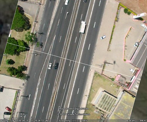

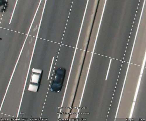
Superoverlay version 1.5.5
Fixed bug with rotation of hi-res images.
Now results of rotation see fine.
We place example of image on
http://gis-center.org/kml/test/duas/BDE00100.454.kmz
Credits by Linomar
You can download file and double click on network link.
Size of example near 4Mb. We place all tiled images into one file as presentation
(use option Packing into KMZ - "pack into one "). For real works this option not need.
1/03/2007
Ground overlay GE&GMaps solution.


We can use one images dataset for groundoverlays in GE and GMaps.
Example:
I use WGS-84 projection. For work need embed image into KMZ file.
You can open one MODIS Terra image in GE and GMaps:
Open KMZ file in GE
Open KMZ file in GMaps
We see right result.
Structure KML+ relative path to image see best. For one image we can connect from many clients (GIS and image viewers). This construction now supported by GE (see example of KML and image) and not supported by GMaps. GMaps support absolute path only. Maybe next version of GMaps can use KML+image construction with relative path.
GMail+Calendar
GMail also support Calendar functions.
You can:
1. Press "Add event info" in top right angle of GMail box
2. Insert link to KML or KMZ file in field "Where"
3. Add time of event and other information.
4. Send this "geo event" to friends.
Your friends can add this event into Calendar, open KML in GE or GMaps.
Enjoy!
PS Also see test Calendar with "geo events" in Googlepages
You can:
1. Press "Add event info" in top right angle of GMail box
2. Insert link to KML or KMZ file in field "Where"
3. Add time of event and other information.
4. Send this "geo event" to friends.
Your friends can add this event into Calendar, open KML in GE or GMaps.
Enjoy!
PS Also see test Calendar with "geo events" in Googlepages
12/31/2006
Google GeoCalendar :)
I test geo events and make Calendar.
You can add New calendar to your Calendars.
Now this calendar have 2 events. You can see events in GMaps by click and select in Where link Map
You can see this calendar as HTML or XML
You can see and use this with Feedburner
You can also insert into your Calendar events only. One or two.
I do not know all ways from this. It's see very interests.
You can add New calendar to your Calendars.
Now this calendar have 2 events. You can see events in GMaps by click and select in Where link Map
You can see this calendar as HTML or XML
You can see and use this with Feedburner
You can also insert into your Calendar events only. One or two.
I do not know all ways from this. It's see very interests.
12/26/2006
Superoverlay.1.5.1. Next version.
Next 1.5.1 version.
New features:
- 'Load/Save' task list as XML file in Scheduler is available

- Custom scheduling type (Launch every hh/mm) is available

New features:
- 'Load/Save' task list as XML file in Scheduler is available

- Custom scheduling type (Launch every hh/mm) is available

12/25/2006
Calendar event test.
Maybe it is simple geo-time-event-toys.
Calendar-GEC-Spreadsheets->Maps
GEC maps event
Test, pls :)
I play with Google Calendar
Calendar-GEC-Spreadsheets->Maps
GEC maps event
Test, pls :)
I play with Google Calendar


12/23/2006
Aeronautical Sectional Charts. Global AIS.

Superoverlay 1.5 Pro support large datasets. We can uses Scheduler and distributed Superoverlay projects.
Matt Fox aka Forkboy2 generate great dataset
About 40,000 tiles all together.
Post about this see in Topographic Map Archive
Great work!
From my archives:
I have experience with generation of Airspace datasets for Global AIS
My post in forum.
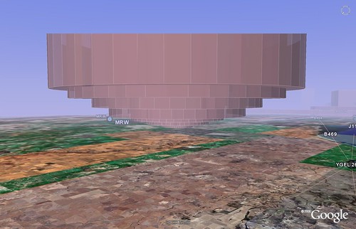 Global AIS KML Download
P.S.
Jeffrey Johnson also compare vector and raster datasets near LAX (Los Angeles international airport). Very nice results!

Thanks!
12/21/2006
KML from Google spreadsheets.
Path calculator.
See also
http://bbs.keyhole.com/ubb/showflat.php?Number=726183
See also
http://bbs.keyhole.com/ubb/showflat.php?Number=726183
11/29/2006
Spreadsheets. New site.
New spreadsheets site-presentation Editgrid KML solutions
AERONET La Jolla
Spreedsheets at calculator links and time animation. AERONET_La_Jolla. Terra. Time animation. 2006.
Pixel size: 2km, 1km, 500m, 250m.
Editgrid XML+XSL.Images group by month.
Credits:
Modis rapid response system.
Download KML: Network link
Path calculator
Spreedsheets at calculator for generation of points, segments and path. All lengths calculate by Great circle distance formula (km, mi).
Download KML : Network link
Fire maps
Spreedsheets at calculator links and time animation.
Editgrid XML+XSL.Images group by month.
Wildfire :
- small 600x300
- med 2048x1024
- large 4096x2048
- xlarge 8192x4096
Credits:
MODIS Rapid Response System Global Fire Maps
Download KML: Network link
Birds fly
Spreedsheets at calculator generate points, segments and path. Time animation. All lengths calculate by Great circle distance formula (km, mi). Generation KML for user datasets. Intergration to Googlegeo ( GE & GMaps ). Datasets and photos by Eugene Potapov.
Download KML: Network link
11/27/2006
Argos. Birds movement. History.
I begin to place in this blog my best publications.
Argos began to support KML format.
This post about Argos tools and results of birds movement.
Information about the authors and the references is given in the layers of the kml-maps or in the included files.
1. Birds movement.
BBS forum
Download:


2. Avian Flu and Birds Migrations: fresh outlook
BBS forum
Download:
3. Steller's Sea Eagle migration. New publication by Eugene Potapov aka Siberian
BBS forum
Download:
4. Birds fly. Animation. Editgrid spreadsheets version
We use ideas KML=XML+XSL with Editgrid
Also we generate realtime graph.

BBS forum
Download:



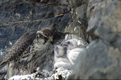
Argos began to support KML format.
This post about Argos tools and results of birds movement.
Information about the authors and the references is given in the layers of the kml-maps or in the included files.
1. Birds movement.
BBS forum
Download:
2. Avian Flu and Birds Migrations: fresh outlook
BBS forum
Download:
3. Steller's Sea Eagle migration. New publication by Eugene Potapov aka Siberian
BBS forum
Download:
4. Birds fly. Animation. Editgrid spreadsheets version
We use ideas KML=XML+XSL with Editgrid
Also we generate realtime graph.

BBS forum
Download:



Subscribe to:
Posts (Atom)